
talking history | syllabi | students | teachers | puzzle | about us
Berkeley Digital Map Collection
http://lib.berkeley.edu/EART/browse.html
Created and maintained by the Earth Sciences and Map Library, University of California, Berkeley.
Reviewed Dec. 23–26, 2005.
Osher Map Library
http://www.usm.maine.edu/maps/web_exhibit.html
Created and maintained by the Osher Map Library and Smith Center for Cartographic Education at the University of Southern Maine, Portland, Maine.
Reviewed Dec. 23–26, 2005.
Federal Township Plats of Illinois, 1804–1891
http://landplats.ilsos.net
Created and maintained by the Illinois State Archives, Springfield, Ill.
Reviewed Dec. 23–26, 2006.
Maps have become ubiquitous on the Internet, with many Web sites providing items of interest to historians. The three sites featured in this review all have useful material, but they vary widely in their level of functionality. Significantly, none of these sites offer interactive mapping.

The Earth Sciences and Map Library from the University of California
The University of California Earth Sciences and Map Library’s site provides quick and easy access to a large number of digitized maps, making it one of the most useful map collections on the World Wide Web. The site offers seven categories of maps: general, topographic, nautical, transportation, thematic, facsimile, and aerial photos. Each category includes maps from a variety of geographical areas and time periods and drawn to different scales.
To locate maps one uses the University of California, Berkeley (UC) library’s Pathfinder system. Users browse through either California (almost 2,150 maps) or non-California (over 7,000) digital maps. In addition, a search function allows users to search by subject. A significant number of the maps are from the David Rumsey Historical Map Collection, an amazingly rich set of eighteenth- and nineteenth-century maps, all beautifully rendered. Links are available to a wide array of other topographic and aerial maps from around the world held by UC, although some resources (for example, Digital Sanborn Maps, 1867–1970) are restricted to UC patrons. Navigation is easy for anyone familiar with online library catalogs, but most browsers will need to disable their computers' pop-up blocker to access the maps.
As with most university map sites, the intended audience consists of people involved in education—students, faculty, researchers—but the site can be used effectively by anyone interested in maps. The functionality of the digital images varies—those using Rumsey’s maps, for example, may employ all the pan-and-zoom tools found in popular sites such as Google Maps, whereas users can only magnify the image of many of the maps scanned by the UC library. Pixel count also varies, with Rumsey’s maps and tools maintaining their readability at a high magnification, whereas other images become increasingly blurry.

“A Map of the World” by Amy Baldwin sc. Age 11 years, 1827.
A map from the Osher Collection.
The Osher Map Library and Smith Center for Cartographic Education at the University of Southern Maine house the only separate rare map library in northern New England. Their collections include original maps, atlases, geography and cartography books, and globes, spanning the years from 1475 to the present and assembled with the aim that they be used for the study and teaching of geography, history, art, and cultural development.
The map library and center regularly mount Web exhibitions. In the ten years since the establishment of the library and center, thirteen exhibitions have examined such topics as nineteenth-century American conceptions of the nation as seen through maps (one union or a confederation of states?), the spatial dimensions of the Jewish and African American diasporas since the fifteenth century, and Portuguese communities in the United States. Each exhibit consists of maps, images, and text. Maps and images typically appear on the left side of the screen, with explanatory text and bibliographic information on the right. Functionality is limited. Users can magnify an image to a size determined by the curator, but they cannot zoom infinitely or pan.
The site is attractively designed and conveys a useful, if limited, amount of information, most often about an image itself and not its interpretation. For instance, the exhibition of maps from the early republic and the nineteenth-century United States purports to illustrate different conceptions of the Union held by contemporaries, but the images and text do not help the viewer see those differences. In that exhibition, the text describes a John Wallis map of the United States at the Peace of Paris (1783) and notes that it reflects the view of a British friend of independence, but despite its declared intention, it does little to explain how the map conveys “political and social as well as geographic meanings.” This lack of clarity, as well as the use of words likely to be unfamiliar to many viewers (for example, “allegorical title-cartouche”) suggests the site is intended more for specialists than students. Unfortunately, the site does not have a search function and will be of little use to scholars who are not already familiar with its contents.
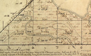
Detail of a township plat of Hyde Park, Chicago, IL.
From the Federal Township Plats of Illinois (1804–1894).
The Land Ordinance of 1785 established the coordinate system so familiar to residents of the Midwest. In preparation for the sale of public lands, surveyors laid out six-square-mile townships in a grid pattern across the territory ceded by Britain in the Peace of Paris. The Federal Township Plats of Illinois, 1804–1891 site, developed by the Illinois State Archives, makes available the 3,457 hand-drawn plat maps of Illinois townships. The maps, which show natural and man-made features and vegetation, are drawn to a scale of two-inches-to-a-mile. For each township, viewers will find two or more maps, each with a different date of certification. The maps contain significant information about the state of the land at the time of American settlement.
County maps are categorized by region (northern, western, central, and southern Illinois), a feature of the site that requires prior knowledge of the state’s geography. No search by county name is possible. By placing the cursor over a county, viewers can access its plat maps, divided into townships and fractional townships. The image is viewable with MrSID, a free Web browser plug-in that provides pan-and-zoom functions. Even at high magnification, image quality is excellent. A useful feature is the legend that appears in a separate pop-up window that describes the symbols found on the maps.
Researchers can learn the names of the first purchasers of the tracts by accessing a linked, downloadable database. Scholars also can obtain a high-quality uncompressed tagged image file format (tiff) file for use within Geographic Information Systems (GIS) by contacting the archives. These two features make the site an especially useful resource for those working with the types of data required for spatial analysis.
David J. Bodenhamer
Indiana University-Purdue
University Indianapolis
Indianapolis, Indiana